Archive for the ‘Habitat improvements’ Category

Return to the Rottal Burn

Monday, September 23rd, 2013

These bulletin blogs represent news about Finavon and the South Esk, and my views as a riparian owner. While I may digress at times to write about other places, these are not the views of any other organisation, nor are they designed to promote the interests of any individual or organisation other than Finavon Castle Water and factors affecting the fishery. Tony Andrews

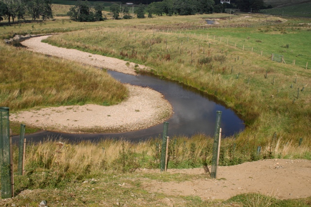
I admire the Rottal Burn restoration Project. With squinted eyes and a bit of imagination, I can surmise what the new course of the burn and its surroundings might look like in 20 years from now. It looks nice, doesn’t it? The burn now has natural features such as a riffle-pool-riffle sequence, bends, deeper pools, gravel bars and erosion zones. It is starting to look natural, which should please the human eye. Furthermore, I have seen both fry and parr in its pools.

Rottal original channel

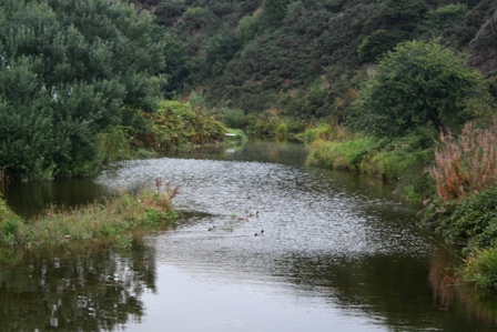
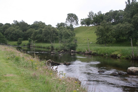
Looking upstream towards Rottal Lodge from the bridge

Rottal original

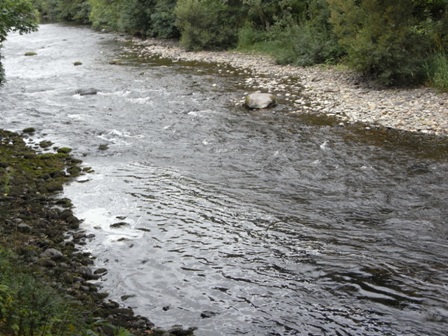
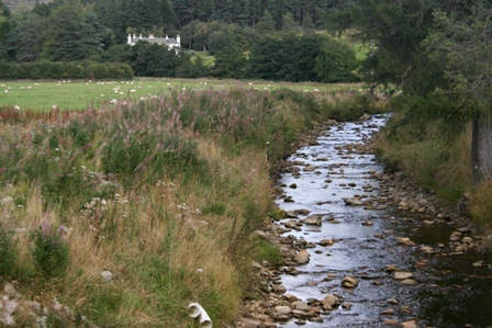
The view downstream from the bridge to the start of the restored section of the Rottal Burn

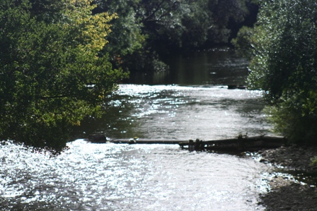
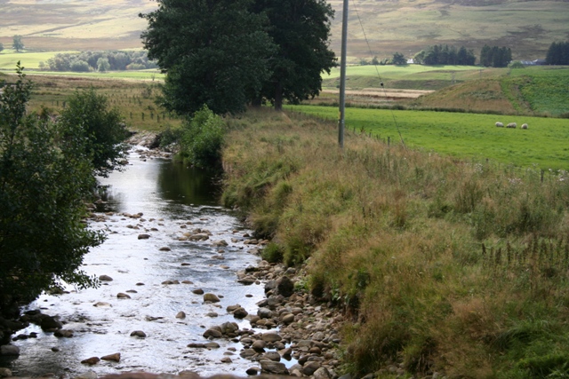
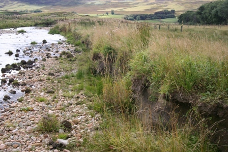
The two photos above show what the Rottal Burn looked like before the restoration in 2012. The straight, dredged channel can clearly be seen, but we should not dismiss the benefits of this high energy, well oxygenated channel that contains ideal sizes of spawning cobbles and gravel. The issue here is not the spawning itself, but the lack of cover and varied habitat for juvenile salmon and sea trout at the fry and parr stages of their growth. The photos were both taken from the bridge at Rottal looking upstream towards the Lodge and downstream towards the confluence. These two photos are a good basis from which to compare the other photos in this blog.

It is well worth reading the ERFT report on the management plan 2009-2012. The report lists the  benefits of the planned restoration as the creation of diverse riparian and aquatic habitat, a return to a more natural flow regime, attenuation of flood peaks, visual enhancement of the area, restoration of functional, sustainable populations of salmon and sea trout, investigate the transfer of freshwater mussels into the burn, develop a demonstration site for future research.

www.erft.org.uk/images/uploads/EsksFMPupdatereport.pdf

Nevertheless, there is good reason to ask some basic questions about the genesis of this project, not least among which is the question, “Why did we do it, as opposed to a more obvious stock enhancement project based on a credible baseline data set?”

Rottal Burn corner pool with depth

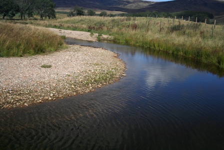
A bend in the newly scoured channel, a naturally depositing gravel bar, and a pool with real depth and bank cover for juvenile salmon and seatrout.

The Rottal Burn restoration was an innovative and costly project, but was this high profile morphological intervention necessary?

Rottal excellent riffle stretch

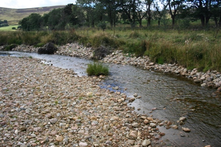
Excellent riffle and cobble stratum for spawning and juveniles.

Did the project provide value for a considerable amount of tax payers’ money? If you had £150,000 (or thereabouts) allocated to enhancing South Esk habitat for salmon and sea trout, is the Rottal project how you would spend it?

Rottal Burn Riffle & bend

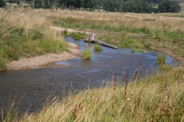
Woody debris and a deeper channel for juveniles. Just one winter of floods and scouring produced this ideal salmonid habitat.

How will we know if it was successful or otherwise?

Rottal Burn 9

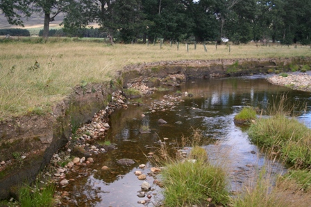
Erosion in progress. Good quality spawning stratum for salmon in a stretch of the new channel which is clearly widening with every flood.

In other words, are there success measures in place and, after one year since the project was completed, are its outcomes becoming apparent?

Rottal Burn 10

Erosion and riffle. The natural process of erosion, a constant and continuous process since the last ice age in Glen Clova, defines the nature of the ‘itinerant’ and meandering Rottal Burn. All we can do is to start the process and then hand it over to natural morphology.

These questions need to be answered in the context of the priorities for restoration of the South Esk catchment as a whole. It might be said that we should have waited until the results of the Marine Scotland (spring) salmon tracking project were available. A question could be asked about baseline data; for example, were data available on redd counts in the dredged channel of the Rottal burn, and the results of juvenile counts in the burn prior to the project? If there are no such data, how can we know whether the project has improved the recruitment performance of the ‘improved’ section of the burn?

Sepajari Rottal

This visually attractive meander had an artificial start, but nonetheless, it is a successful attempt at achieving habitat diversity.

This project should be the start of a debate, not its conclusion. Visually it is fair to say the Rottal Burn project has so far been a success. We need to bear in mind what it looked like before the restoration – a straight dredged channel of one kilometer. Ideally we should now see:

a) reports on salmon and trout spawning and parr recruitment and, if possible, a comparison with what was there before

b) reports on improving fauna and flora diversity, including invertebrates and intoducing the freshwater mussel. Is there better biodiversity than before the project? A step-by-step monitoring of progress would be helpful.

c) comparisons with other tributaries in the upper and middle catchment and the populations they support.

Rottal Wildlife observation hut (2)

Wildlife observation hut and ‘Field Classroom’ overlooking the restored Rottal Burn

Having got ourselves enthused with the innovation, we now need some cool, objective data to give us a proper evaluation of this project. I look forward to that, but I recognise that it may take time.

TA 23/9

“Rivers In Between” The River Bervie

Sunday, September 22nd, 2013

These bulletin blogs represent news about Finavon and the South Esk, and my views as a riparian owner. While I may digress at times to write about other places, these are not the views of any other organisation, nor are they designed to promote the interests of any individual or organisation other than Finavon Castle Water and factors affecting the fishery. Tony Andrews

Rivers regularly in the news such as the Tay, Dee and North and South Esks, of which all except the North Esk are EU designated Special Areas of Conservation (SACs), may draw attention away from little rivers such as the Lunan, Cowie and Bervie, which have unique catchments and their own estuaries into the North Sea. It is easy to forget them. This blog is about the River Bervie and the problem it currently has with a naturally recurring impassable barrier to salmon and sea trout as it enters the North Sea.

You may wonder what the problems of the River Bervie have to do with FCW and the South Esk. If you are having such a thought, do read on!

The River Bervie.

The Bervie rises in the foothills of the Grampian Mountains and flows for about 20 miles through upland farms and forestry before entering the agricultural land of the Mearns and flowing into the North Sea at Inverbervie. While the catchment is quite small, at about 85 square miles, the river is prone to big flood events from the high ground of the Eastern Grampians, as are neighbouring rivers the North Esk, the Cowie and (on the other side of the catchment watershed) the River Feugh, a tributary of the Aberdeenshire Dee.

The estuary is located between Stonehaven and Montrose. Its neighbouring major rivers are the North Esk to the south and the Aberdeenshire Dee to the north. The Bervie has populations of Atlantic salmon, sea trout and indigenous brown trout and is fished regularly by local angling clubs. Recently the Esks Rivers and Fisheries Trust, which is responsible for habitat management of the Bervie, mounted a successful programme to eradicate a serious invasion of Japanese knotweed from the banks of the middle river.

1. View of Bervie Estuary

General view of the River Bervie estuary ,showing the shingle bar that denies access of salmon and sea trout to the river.

Yesterday, prompted by an e-mail from a concerned angler, I visited the estuary of the River Bervie in Inverbervie. The photos in this bulletin show all too clearly the problems of this little Mearns river as it enters the sea.

I have fished the Bervie for wild trout for many years, so I can vouch for the excellent habitat the river provides for migratory and indigenous wild salmonids at all stages of their freshwater growth. It is a gem of a small river!

3. Detail of obstructed access

The photo above shows in detail the problem faced by migrating salmon, grilse and sea trout attempting to access the river. Strong winds and tides have swept huge quantities of heavy shingle (cobbles with an average diameter of 2 to 3″) into an extended ‘mound’ that completely blocks access. The photo was taken at high tide.

I remember seeing salmon redds in the cobble sections of the middle river pools  during the winter months. There have been many occasions in summer months when I have caught more than a dozen small wild trout on a dry fly in its pools and riffles. The biggest wild trout I have ever caught in the river weighed less than one pound! The Bervie is a fertile and productive small river with a deceptively steep catchment gradient, and consequent high energy flood events. It is quite a dynamic river.

4. Lagoon formed by shingle dam

The photo above shows the lagoon caused by the shingle barrier at high tide preventing the river reaching the sea by percolating through the cobbles of the beach. The water is backed up to create this area of fresh water.

So salmon do get into the river, and the problems of natural estuary obstructions are nothing new. In the past bulldozers have been deployed to shift the shingle to enable passage by migrating fish to and from the river. I do not know why this hasn’t happened in 2013. No doubt generations of Bervie salmon have adjusted their run timings to enable them to make use of good levels of freshwater and high tides in the winter, spring and autumn months.

8. Shingle Beach barrier

This photo shows how the banked-up shingle of rounded cobbles and large diameter gravel causes a barrier to fish migration. The picture was taken at high tide when river water is unable to reach the sea by percolating through the shingle.

I believe that the issue is not the shingle barrier itself (although it would of course be better if it weren’t there) but that mixed stocks coastal netting in the districts of the North and South Esks is probably causing potentially serious damage to  Bervie salmon and sea trout stocks. It is the combination of that unknown level of exploitation with the effect of the estuarine barrier and low water attrition of numbers of waiting fish that should be causes for concern.

7. View of sea side of shingle

Photo of the sea side of the shingle barrier with an angler spinning at the very point where the river channel should enter the sea. While I was there I saw a number of grilse and sea trout leaping clear of the water a few feet away from the steep shingle bank.

Looking upstream towards viaduct

The photo above is the view upstream from the footbridge at the sea pool of the River Bervie. The river’s water has been backed up by the high tide, which prevents the fresh water reaching the sea by seeping through the shingle barrier.

The Marine Scotland South Esk Tracking Project confirmed in 2012 that the coastal nets at Usan, south of Montrose, are killing early running multi sea-winter salmon from a range of rivers, including the Don, Dee, North Esk, South Esk and Tay.

The small east coast rivers, of which the Bervie is one, tend to have summer and autumn runs of salmon and grilse, rather than early running spring salmon. Because the MSS S Esk project focuses on tagging spring salmon (up to 31st May) it is therefore unlikely that any salmon or grilse bound for the Bervie were tagged. However, given the spread of exploitation by the Usan fishery, it is very likely that Bervie fish are killed by the nets later in the season. In a dry year, as 2013 has been, fish arriving off the coast are reluctant or unable to enter rivers affected by low levels of flow and high water temperatures. Fish that hang around in the sea, close to river estuaries, waiting for a summer freshet are exceptionally vulnerable to predation, disease, netting and natural stresses (such as the large amount of energy required for osmo-regulation).

The situation for the Bervie is exacerbated by the naturally occurring blockage of the estuary by beach shingle. The level of risk for the Bervie’s salmon stock, caused by the inability of fish to enter the river, at the same time as natural attrition in a dry year and unknown impacts from lethal exploitation by the Usan nets, may threaten the viability of the river to produce sufficient ova to ensure natural sustainability. That surely is a serious issue that needs to be addressed soon? It is not only the South Esk that suffers unknown levels of depredation of its salmon populations. Indeed, some people might with justification argue that it is “the rivers in between” that are most threatened by continuation of mixed stocks netting.

TA 22 September 2013


Low water & a programme of maintenance

Saturday, September 21st, 2013

These bulletin blogs represent news about Finavon and the South Esk, and my views as a riparian owner. While I may digress at times to write about other places, these are not the views of any other organisation, nor are they designed to promote the interests of any individual or organisation other than Finavon Castle Water and factors affecting the fishery. Tony Andrews

There have been a few fish caught by intrepid tenants during September, but it has been hard going. Despite the low water and reluctance of fish to show themselves, or move to the fly, we have seen fish in the main pools. As usual Melgund has held a few MSW salmon throughout the three months of low water. From the Aqueduct it has been possible to observe both grilse and large salmon, plus a few sea trout in the one to three pounds weights category, and last week we saw a reasonably fresh cock salmon of about 14lbs lying stationary just above the big lie boulder downstream of the aqueduct. Other pools such as Tyndals, Willows and Red Brae have all held fish – both salmon and sea trout – in varying numbers throughout the summer.

Exif_JPEG_PICTURE

The webcam boulder at Tyndals (Milton Beat) in summer low conditions. The water level has been here, or here abouts, all summer. In fact there has been a reasonable flow all summer long, albeit a low water flow.

It is natural that some summers are dry, as this summer has been. The fact is that this season has been the driest in terms of flow in the South Esk for quite a number of years. You only have to look at the SEPA graphs in the river levels section of the Fishpal website to appreciate how short of water the river has been during this summer. The result has been FCW’s worst catch numbers for 30 years: a reminder to us all that we are dealing with a wild resource that is subject to the vagaries of weather conditions.

Beechesin very low water 9.13

This photograph was taken from the Aqueduct while looking into the bright sun of early afternoon in September. It shows the streamy water of Beeches Pool in very lowwater, one of the best sections of FCW for salmon and sea trout in all but flood conditions. The lie upstream of the Aqueduct (just out of the foot of this photo) is where John Wood caught the first spring salmon of 2013 – a beautiful 17lbs fish – and where in 2012 Alec Towns lost a very big fish (est 30lbs) when his rod shattered after a 40 minute fight.

I feel some reassurance that there are uncertainties when dealing with the natural world. I would rather have it that way than predictable numbers of fish caught in a stocked river or loch. Managing a wild fishery is full of uncertainties. The best we can do is to make sure that the habitats over which we have control are in the best possible condition for returning adult fish, spawning and juveniles.

Below Gella

This is the South Esk in Glen Clova, just downstream of Gella Bridge in low water conditions. and the Rottal Burn Project are examples of efforts being made by the Esk Rivers and Fisheries Trust to improve the environment in this much abused part of the upper catchment.

In that context the summer has been a good time to improve the fishery by carrying out minor manual repairs to eroded banks, eradicating most of the giant hogweed, Japanese knotweed and a small amount of Himsalayan balsam. Filling in the gaps in boulder groynes with small stones to trap silt and provide placesto plant willow pegs in the autumn and winter has been an important part of our maintenance programme. The low water has also enabled us to remove debris and other rubbish from the bed of the river: pieces of wire fencing, bottles, tin cans, bits of cars and waterlogged timbers trapped against midstream boulders have all been removed. Other maintenance has included safety checks on bridges and huts, repairs to flood damaged infrastructure,  wood protection applied, and the usual round of grass cutting and cutting back intruding branches on banks and along access tracks.

Exif_JPEG_PICTURE

The photo above shows the repair to the south support of the Haughs Aqueduct, which we should now describe as a ‘footbridge’ after FCW acquired it last year. It used to be the pipe bridge that brought water from Glen Quiech to Arbroath. The water supply has been rationalised and the aqueduct is now redundant. It is a well engineered 1950s structure which provides safe & private access across the river at Haughs for anglers. To take this photo the water level had to be very low, so there have been plenty of opportunities this summer!

We now await water and maybe some late autumn fish. If neither arrives it really doesn’t matter: there’s always next season! What I can say is that the river and its surroundings at Finavon have never been in better condition, and I keep reminding myself that our freshwater mussels are recovering – and that surely is a fine indicator of success!

TA 21/9