These bulletin blogs represent news about Finavon and the South Esk, and my views as a riparian owner. While I may digress at times to write about other places, these are not the views of any other organisation, nor are they designed to promote the interests of any individual or organisation other than Finavon Castle Water and factors affecting the fishery. Tony Andrews
Rivers regularly in the news such as the Tay, Dee and North and South Esks, of which all except the North Esk are EU designated Special Areas of Conservation (SACs), may draw attention away from little rivers such as the Lunan, Cowie and Bervie, which have unique catchments and their own estuaries into the North Sea. It is easy to forget them. This blog is about the River Bervie and the problem it currently has with a naturally recurring impassable barrier to salmon and sea trout as it enters the North Sea.
You may wonder what the problems of the River Bervie have to do with FCW and the South Esk. If you are having such a thought, do read on!
The River Bervie.
The Bervie rises in the foothills of the Grampian Mountains and flows for about 20 miles through upland farms and forestry before entering the agricultural land of the Mearns and flowing into the North Sea at Inverbervie. While the catchment is quite small, at about 85 square miles, the river is prone to big flood events from the high ground of the Eastern Grampians, as are neighbouring rivers the North Esk, the Cowie and (on the other side of the catchment watershed) the River Feugh, a tributary of the Aberdeenshire Dee.
The estuary is located between Stonehaven and Montrose. Its neighbouring major rivers are the North Esk to the south and the Aberdeenshire Dee to the north. The Bervie has populations of Atlantic salmon, sea trout and indigenous brown trout and is fished regularly by local angling clubs. Recently the Esks Rivers and Fisheries Trust, which is responsible for habitat management of the Bervie, mounted a successful programme to eradicate a serious invasion of Japanese knotweed from the banks of the middle river.
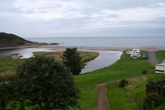
General view of the River Bervie estuary ,showing the shingle bar that denies access of salmon and sea trout to the river.
Yesterday, prompted by an e-mail from a concerned angler, I visited the estuary of the River Bervie in Inverbervie. The photos in this bulletin show all too clearly the problems of this little Mearns river as it enters the sea.
I have fished the Bervie for wild trout for many years, so I can vouch for the excellent habitat the river provides for migratory and indigenous wild salmonids at all stages of their freshwater growth. It is a gem of a small river!
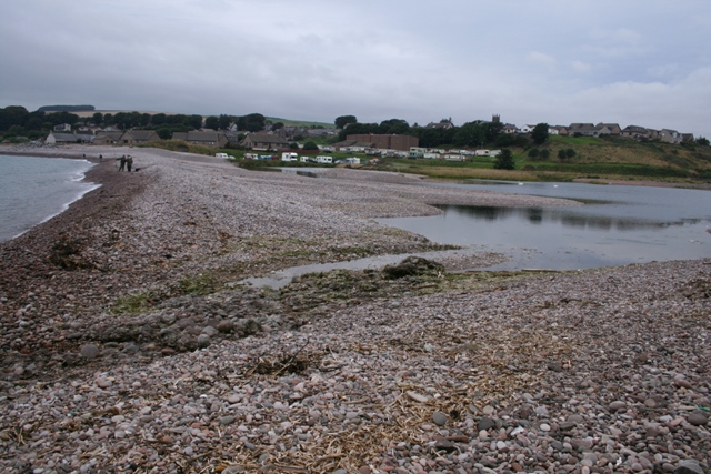
The photo above shows in detail the problem faced by migrating salmon, grilse and sea trout attempting to access the river. Strong winds and tides have swept huge quantities of heavy shingle (cobbles with an average diameter of 2 to 3″) into an extended ‘mound’ that completely blocks access. The photo was taken at high tide.
I remember seeing salmon redds in the cobble sections of the middle river pools during the winter months. There have been many occasions in summer months when I have caught more than a dozen small wild trout on a dry fly in its pools and riffles. The biggest wild trout I have ever caught in the river weighed less than one pound! The Bervie is a fertile and productive small river with a deceptively steep catchment gradient, and consequent high energy flood events. It is quite a dynamic river.
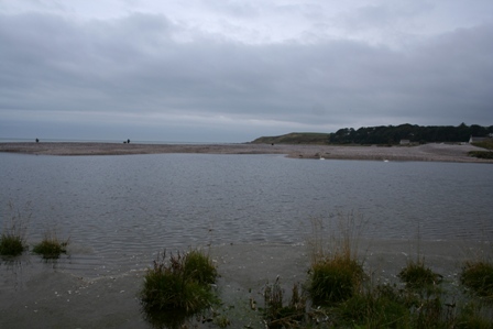
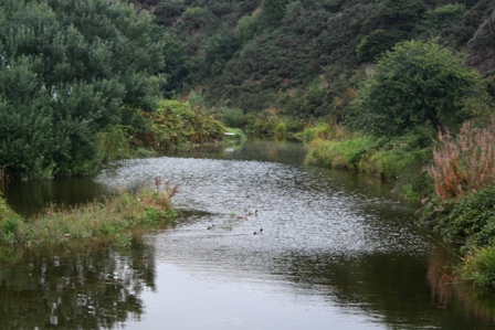
The photo above shows the lagoon caused by the shingle barrier at high tide preventing the river reaching the sea by percolating through the cobbles of the beach. The water is backed up to create this area of fresh water.
So salmon do get into the river, and the problems of natural estuary obstructions are nothing new. In the past bulldozers have been deployed to shift the shingle to enable passage by migrating fish to and from the river. I do not know why this hasn’t happened in 2013. No doubt generations of Bervie salmon have adjusted their run timings to enable them to make use of good levels of freshwater and high tides in the winter, spring and autumn months.
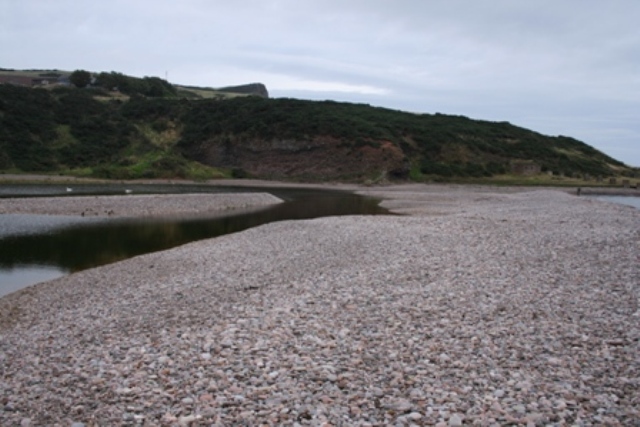
This photo shows how the banked-up shingle of rounded cobbles and large diameter gravel causes a barrier to fish migration. The picture was taken at high tide when river water is unable to reach the sea by percolating through the shingle.
I believe that the issue is not the shingle barrier itself (although it would of course be better if it weren’t there) but that mixed stocks coastal netting in the districts of the North and South Esks is probably causing potentially serious damage to Bervie salmon and sea trout stocks. It is the combination of that unknown level of exploitation with the effect of the estuarine barrier and low water attrition of numbers of waiting fish that should be causes for concern.
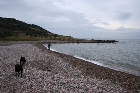
Photo of the sea side of the shingle barrier with an angler spinning at the very point where the river channel should enter the sea. While I was there I saw a number of grilse and sea trout leaping clear of the water a few feet away from the steep shingle bank.
The photo above is the view upstream from the footbridge at the sea pool of the River Bervie. The river’s water has been backed up by the high tide, which prevents the fresh water reaching the sea by seeping through the shingle barrier.
The Marine Scotland South Esk Tracking Project confirmed in 2012 that the coastal nets at Usan, south of Montrose, are killing early running multi sea-winter salmon from a range of rivers, including the Don, Dee, North Esk, South Esk and Tay.
The small east coast rivers, of which the Bervie is one, tend to have summer and autumn runs of salmon and grilse, rather than early running spring salmon. Because the MSS S Esk project focuses on tagging spring salmon (up to 31st May) it is therefore unlikely that any salmon or grilse bound for the Bervie were tagged. However, given the spread of exploitation by the Usan fishery, it is very likely that Bervie fish are killed by the nets later in the season. In a dry year, as 2013 has been, fish arriving off the coast are reluctant or unable to enter rivers affected by low levels of flow and high water temperatures. Fish that hang around in the sea, close to river estuaries, waiting for a summer freshet are exceptionally vulnerable to predation, disease, netting and natural stresses (such as the large amount of energy required for osmo-regulation).
The situation for the Bervie is exacerbated by the naturally occurring blockage of the estuary by beach shingle. The level of risk for the Bervie’s salmon stock, caused by the inability of fish to enter the river, at the same time as natural attrition in a dry year and unknown impacts from lethal exploitation by the Usan nets, may threaten the viability of the river to produce sufficient ova to ensure natural sustainability. That surely is a serious issue that needs to be addressed soon? It is not only the South Esk that suffers unknown levels of depredation of its salmon populations. Indeed, some people might with justification argue that it is “the rivers in between” that are most threatened by continuation of mixed stocks netting.
TA 22 September 2013